2022年1月14日,北斗卫星导航系统工程总设计师、中国工程院院士杨长风在《GPS WORLD》杂志发表文章《2022方向:进入全球服务新时代的北斗系统》,介绍了北斗系统目前的系统性能与服务、应用产业发展、国际合作情况,并展望了北斗系统的后续计划。
2022方向:进入全球服务新时代的北斗系统
2020年,北斗三号全球卫星导航系统建成开通。2021年,北斗系统不断提升性能、拓展应用、深化合作,持续、稳定、快速发展。
一、系统性能与服务
当前,北斗系统在轨运行服务卫星共45颗,包括15颗北斗二号卫星和30颗北斗三号卫星,联合为用户提供7种服务。具体包括:面向全球,提供定位导航授时、全球短报文通信和国际搜救3种服务;面向亚太地区,提供星基增强、地基增强、精密单点定位和区域短报文通信4种服务。
系统开通服务一年多来,运行连续稳定,卫星可用性均值优于0.99、连续性均值优于0.999。定位导航授时服务,经全球连续监测评估系统实测,全球范围水平定位精度约1.52米,垂直定位精度约2.64米(B1C信号单频、95%置信度);测速精度优于0.1米/秒,授时精度优于20纳秒,亚太区域精度更优。
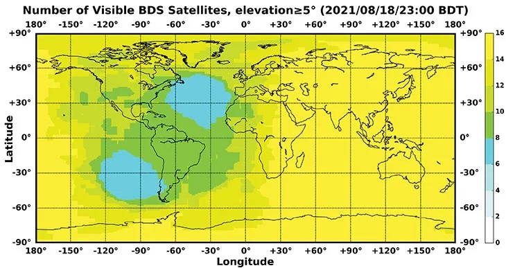
图1 全球范围可见北斗系统卫星数
上图是2021年11月18日北斗时0:00,北斗系统全球范围可见卫星数。其中,在亚洲太平洋的部分区域可见卫星数超过20颗(图片及信息来源:www.csno-tarc.cn)
全球短报文服务,通过14颗MEO卫星,已为授权用户、低轨卫星提供试用服务,单次最大通信能力560比特,约40个汉字;国际搜救服务,通过6颗MEO卫星提供符合全球卫星搜救系统标准的406MHz前向报警服务(MEOSAR),以及通过24颗MEO和3颗IGSO卫星提供基于B2b信号的返向链路服务(RLS),目前已完成测试验证,正在协调加入国际搜救卫星组织;星基增强服务,中国民用航空管理局正在组织开展星地一体化测试评估,定位精度、告警时间、完好性风险等指标满足要求;地基增强服务,利用在中国范围内建成的框架网基准站和区域网基准站,面向行业和大众用户提供实时厘米级、事后毫米级高精度服务;精密单点定位服务,通过3颗GEO卫星播发精密单点定位信号,实测水平定位精度0.24米,垂直定位精度0.41米(95%置信度),收敛时间少于20分钟;区域短报文通信,短报文通信进入大众手机已完成测试验证,后续计划将规模化应用。
二、应用产业发展
北斗规模应用已进入市场化、产业化、国际化发展的关键阶段。2020年中国卫星导航与位置服务产业总体产值增速继续增长,较2019年增长约16.9%,达到4033亿元人民币(约632亿美元)。基础产品方面,支持北斗三号系统的北斗/GNSS基础芯片、模块、板卡、天线等关键技术全面突破,国外主流芯片全部支持北斗系统,建立实施北斗基础产品认证检测制度。大众应用方面,北斗系统日益融入普通百姓的日常生活,正在成为智能手机、可穿戴设备等大众消费产品定位功能标准配置。小米、华为、苹果、三星等智能手机厂商均支持北斗系统。2021年前三季度,中国境内申请入网支持北斗定位的智能手机款型占比达到72.3%,出货量占比达到93.5%。北斗地基增强功能已进入智能手机,可实现1米级高精度定位,正在中国多个城市开展车道级导航试点应用。行业应用方面,北斗系统已全面服务于交通运输、公共安全、救灾减灾、农林牧渔等行业,加速融入电力、金融、通信等基础设施。特别是在科技抗疫斗争中,北斗精准定位,助力抗疫物资高效供应流转。当前,基于北斗系统的土地确权、精准农业、智慧港口等解决方案已服务于亚洲、东欧、非洲等地各国经济社会发展,北斗产品已在全球一半以上国家和地区得到应用。
三、国际合作
北斗始终坚持开放合作、资源共享的发展理念,积极务实开展国际交流与合作,为和平利用外层空间贡献中国力量。
双边方面,中俄卫星导航重大战略合作项目委员会第八次会议于2021年10月召开,双方联合编制并签署《2021至2025年中俄卫星导航领域合作路线图》,为未来五年中俄卫星导航合作提供规划指导;与阿根廷、南非签署卫星导航领域合作文件,正式建立常态化合作机制。
多边方面,持续参与联合国全球卫星导航系统国际委员会(ICG)系列活动,倡导在多边场合下共商共促全球卫星导航事业。成功举办第一届中非北斗合作论坛、第三届中阿北斗合作论坛、第二届中国-中亚北斗合作论坛以及迪拜世界博览会“北斗日”主题活动,分享北斗系统建设发展成果。
逐渐融入国际标准,持续推进北斗系统进入民航、海事、搜救卫星、移动通信、电工委员会等国际组织标准体系,多项支持北斗系统的国际标准先继发布。中国政府目前已草拟提交国际民航组织的承诺函,承诺北斗系统将为全球民航用户免费提供基本导航服务。国际航标协会正式发布包含北斗星基增强系统的标准,标志着全球海事用户可据此开展北斗星基增强海事应用。国际移动通信第三代合作伙伴计划已启动北斗三号B2a、B3I新信号的标准化工作。国际电工委员会发布的全球海上遇险与安全系统应急示位标检测标准中,将支持北斗接收机和北斗搜救服务。
稳步推进法治建设,中国政府高度重视并全面推进卫星导航法治建设,基本形成以国家宏观政策为主导、行业和地方政策法规为主体的北斗法律制度体系。积极推进《中华人民共和国卫星导航条例》立法进程,保障卫星产业健康、快速、持续发展。2021年5月,发布《北斗卫星导航系统法治建设报告》。
四、后续计划
后续,北斗系统一方面将保证系统运行稳定,另一方面将抓好备份卫星研制,完成备份卫星生产、状态优化和地面测试工作,根据需要发射性能更优的北斗三号备份卫星,进一步提高星座可靠性。秉承“中国的北斗、世界的北斗、一流的北斗”发展理念。弘扬“自主创新、开放融合、万众一心、追求卓越”的新时代北斗精神,服务全球,造福人类!
作者:北斗卫星导航系统工程总设计师、中国工程院院士 杨长风
英文全文如下:
Directions 2022: BDS enters new era of global services
Yang Changfeng is BeiDou’s Chief Architect. (Photo: BeiDou Navigation Satellite System)
Construction of the BeiDou Navigation Satellite System (BDS-3) has been completed. The system was formally commissioned on July 31, 2020. In 2021, BDS continued to improve performance, expand applications and deepen cooperation, and has achieved sustained, stable and rapid development.
System Performance and Services
Currently, 45 BDS satellites are operational in orbit — 15 BDS-2 satellites and 30 BDS-3 satellites jointly provide seven types of services to users. Specifically, for the entire planet, the system provides three services:
Positioning, navigation and timing (PNT).
Global short-message communication.
International search-and-rescue (SAR) services.
For the Asia-Pacific region, the system provides four additional services:
Satellite-based augmentation.
Ground-based augmentation.
Precise point positioning.
Regional short-message communication services.
The system has been operating continuously and stably since commissioning, with the average value of satellite availability better than 0.99 and the average value of satellite continuity better than 0.999.
PNT Service. As actually measured by the International GNSS Monitoring and Assessment System (iGMAS), the global horizontal positioning accuracy is about 1.52 meters, the vertical positioning accuracy is about 2.64 meters (B1C signal single frequency, 95% confidence), the velocity measurement accuracy is better than 0.1 m/s, and timing accuracy is better than 20 nanoseconds. The performance is better in the Asia-Pacific region.
FIGURE 1 shows the number of visible BDS satellites worldwide at BDT 00:00 on Nov. 18, 2021. Among them, the number of visible BDS satellites exceeds 20 in some areas of the Asia-Pacific region.
figure 1. Number of visible BDS satellites, elevation ≥5° (2021/11/18/00:00 BDT). (CREDIT: www.csno-tarc.cn)
Global Short Message Communication Service. Trial service is provided through 14 medium-Earth-orbit (MEO) satellites for authorized users and low-orbit satellites, with a maximum single-message length of 560 bits, equivalent to about 40 Chinese characters.
Search-and-Rescue Service. A COSPAS/SARSAT-compliant MEOSAR service is provided by six payloads deployed on six MEO satellites. A B2b signal-based Return Link Service (RLS) is provided through 24 MEO and three IGSO satellites, which have completed testing and verification and are in the process of coordination within the framework of COSPAS-SARSAT.
Satellite-Based Augmentation Service. China’s Civil Aviation Administration is organizing satellite-ground integrated test and evaluation, and the positioning accuracy, alarm time, integrity risk and other indicators meet the requirements.
Ground-Based Augmentation Service. Real-time centimeter-level and post-processing millimeter-level services are provided for industrial and public users, based on the regional network reference stations built in China.
Precise Point Positioning Service. PPP signals are broadcast by three GEO satellites. The measured horizontal positioning accuracy is 0.24 m, the vertical positioning accuracy is 0.41 m (95% confidence), and the convergence time is less than 20 minutes.
Regional Short Message Communication Service. The short-message communication function has been tested and verified for integration into public mobile phones; large-scale application is planned.
Development of the Applications Industry
Large-scale applications of BDS have entered a critical stage of liberalization, industrialization and internationalization. The overall output value of China’s satellite navigation and location-based service industry continued to grow in 2020, up to 403.3 billion yuan (US$63.2 billion), which is about 16.9% more than its value in 2019. In terms of BDS-3-enabled basic products, an industrial chain is gradually maturing, comprised of BDS/GNSS basic chips, modules, boards, antennas and other components.
The certification and testing system of basic BDS products has been established and implemented. BDS is already supported by most mainstream chips. BDS is increasingly being integrated into the daily life of the general public. It is becoming the standard configuration for positioning functions of smartphones and other mass-market products.
Smartphone manufacturers such as Xiaomi, Huawei, Apple and Samsung already support BDS. In the first three quarters of 2021, among all types of smartphones applying for online access in China, 72.3% supported positioning function based on BDS, accounting for 93.5% of the total sales volume. The BDS ground-based augmentation function has been introduced into smartphones to achieve high-precision positioning at the 1-meter level; lane-level navigation is being piloted in several cities in China.
In terms of industrial applications, BDS has fully served multiple industries including transportation, public security, disaster relief, agriculture, forestry, animal husbandry and fishing. It has accelerated the integration into electricity, finance, communications and other infrastructure. In particular, in the fight against COVID-19 through scientific and technological approaches, BDS-based precise positioning has facilitated the efficient supply and circulation of anti-epidemic materials.
BDS-based solutions for land rights determination, precision agriculture and smart ports have served the economic and social development of countries in Asia, Eastern Europe and Africa, and BDS-based products have been applied in more than half of the world’s countries and regions.
International Cooperation
BDS has always adhered to the development concepts of openness, cooperation and resource sharing; actively carried out practical international exchanges and cooperation; and contributed to China’s peaceful use of outer space.
Bilaterally, the Eighth Meeting of the China-Russia Project Committee on Major Strategic Cooperation in Satellite Navigation was held in October 2021. Both sides jointly formulated and signed the Roadmap for Cooperation in the Field of Satellite Navigation from 2021 to 2025, providing planning and guidance for China-Russia satellite navigation cooperation in the next five years. Also, China’s Satellite Navigation Office signed a memorandum of understanding on satellite navigation cooperation with the National Committee on Space Activities of the Republic of Argentina and the South African National Space Agency, and formally established a regular cooperation mechanism.
BDS is gradually being integrated into international standards, and is steadily promoting ratification by international standards bodies, including in the civil aviation, maritime, SAR, mobile communications and electrotechnical fields. Several international standards supporting BDS have been released. The Chinese government has drafted a letter of commitment to the International Civil Aviation Organization (ICAO), stating that BDS will provide basic services free of charge to civil aviation users around the world. The International Association of Marine Aids to Navigation and Lighthouse Authorities (IALA) has officially issued a standard that ratifies BDSBAS, so that global marine users can carry out applications based on it. The Third Generation Partnership Project has started the standardization of BDS-3’s B2a and B3I signals. In the detection standard for Indicating Radio Beacon Locator of the Global Maritime Distress and Safety System issued by the International Electrotechnical Commission, BDS receivers and BDS-based SAR services will be supported.
The Chinese government is steadily advancing the rule of law, attaching great importance to and comprehensively promoting the rule of law for satellite navigation. A legal system on BDS has been formed, consisting of national policies, industrial and local policies and regulations, and more. The legislative process of the Satellite Navigation Regulations of the People’s Republic of China has been actively promoted to ensure the healthy, rapid and sustainable development of the satellite industry. In May 2021, China issued a development report on the rule of law of BDS.
Follow-Up Plan
In the future, on the one hand BDS will ensure stable operation, while on the other hand it will focus on the development of backup satellites, and complete the production, state optimization and ground testing of backup satellites. Backup BDS-3 satellites with better performance will be launched as needed to further improve the reliability of the constellation. By adhering to the development concept of “BDS is developed by China, dedicated to the world and aiming to be first class,” carrying forward the BDS spirit of the new era of “independent innovation, open integration, unity of all, pursuit of excellence,” BDS will serve the world and benefit all humankind.
Number of BDS-3 satellites in orbit: 30
Signals broadcast: B1I, B3I, B1C, B2a, and B2b
Yang Changfeng is chief architect of the BeiDou Navigation Satellite System and a Chinese Academy of Engineering academician.